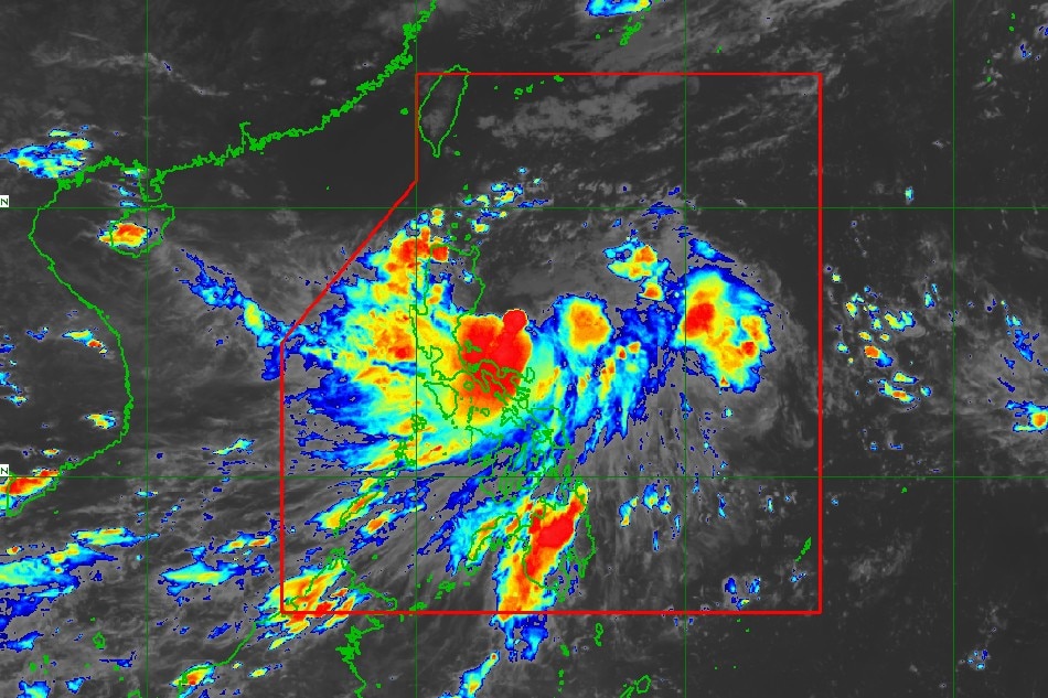
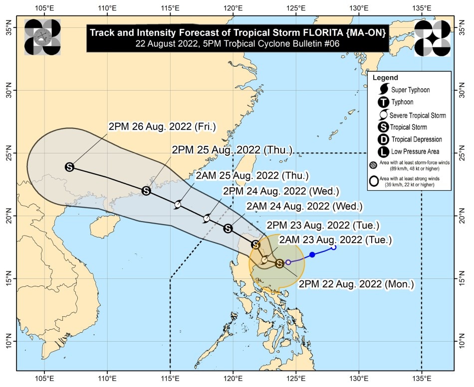
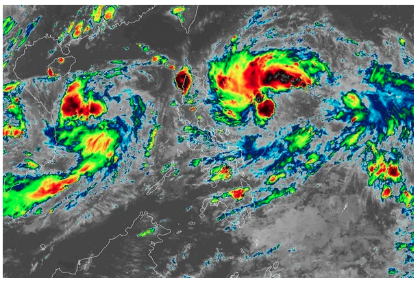
MANILA (UPDATED) - More areas in the Cagayan Valley and Cordillera regions were placed under Tropical Cyclone Wind Signal No. 2 on Monday afternoon as Tropical Storm Florita continues to move west over the Philippine Sea, state weather bureau PAGASA said.
In its 5 p.m. bulletin, PAGASA said Florita was last located 155 kilometers east of Casiguran, Aurora, packing maximum sustained winds of 75 kilometers per hour near the center, with gusts of up to 90 kph.
It was moving west at 15 kph.
PAGASA said Signal No. 2 is currently hoisted over the following areas:
- * Cagayan
- * Isabela
- * Quirino
- * eastern portion of Nueva Vizcaya (Alfonso Castaneda, Dupax del Norte, Kasibu, Quezon, Bambang, Ambaguio, Bayombong, Solano, Villaverde, Bagabag, Diadi)
- * Apayao
- * eastern portion of Abra (Tubo, Boliney, Bucloc, Daguioman, Sallapadan, Licuan-Baay, Malibcong, Lacub, Tineg, Lagangilang, Bucay, Manabo, Luba)
- * Kalinga
- * Mountain Province
- * Ifugao
- * northern and central portions of Aurora (Dilasag, Casiguran, Dinalungan, Dipaculao, Baler, Maria Aurora)
Areas under Signal No. 2 may experience winds greater than 61 kph up to 120 kph in at least 24 hours. The strong winds can peel off old roofs and tilt or down wooden electric posts, and damage banana plants, rice, corn, and trees.
Meanwhile, Signal No. 1 was raised over the following areas:
- * Babuyan Islands
- * rest of Nueva Vizcaya,
- * rest of Abra
- * Benguet
- * Ilocos Norte
- * Ilocos Sur
- * La Union
- * eastern portion of Pangasinan (Urbiztondo, Bayambang, Bautista, Alcala, Santo Tomas, Rosales, Balungao, Umingan, San Quintin, Natividad, Tayug, San Nicolas, San Manuel, Asingan, San Carlos City, Lingayen, Binmaley, Basista, Malasiqui, Villasis, Santa Maria, City of Urdaneta, Binalonan, Laoac, Manaoag, Pozorrubio, Sison, San Fabian, San Jacinto, Mapandan, Santa Barbara, Mangaldan, Dagupan City, Calasiao)
- * eastern portion of Tarlac (San Manuel, Moncada, Anao, Paniqui, Ramos, Gerona, Pura, Victoria, City of Tarlac, Concepcion, La Paz)
- * Nueva Ecija
- * rest of Aurora
- * eastern portion of Pampanga (Magalang, Arayat, Candaba)
- * eastern portion of Bulacan (San Miguel, Doña Remedios Trinidad, San Ildefonso, San Rafael, Angat, Norzagaray, City of San Jose del Monte)
- * northeastern portion of Rizal (Rodriguez, San Mateo, City of Antipolo, Tanay, Baras)
- * northern portion of Quezon (Infanta, General Nakar, Real) including Polillo Islands
- * northern portion of Laguna (Santa Maria, Famy, Siniloan, Pangil, Pakil, Paete)
- * Camarines Norte
PAGASA said moderate to intense rains may prevail over Camarines Norte, Camarines Sur, and Quezon including Polillo Islands, while moderate to heavy rains are expected over the Ilocos Region, Apayao, and Cagayan.
Light to moderate with at times heavy rains may also be experienced over Central Luzon, Batanes, Isabela, Mindoro Provinces, Romblon, Marinduque, Metro Manila, and the rest of CALABARZON, and Bicol Region.
From Tuesday, heavy to intense with at times torrential rains may persist over Cagayan, Isabela, Batanes, Cordillera Administrative Region, and Ilocos Region, while moderate to heavy with at times intense rains may be experienced over Aurora, Zambales, and Bataan.
Light to moderate with at times heavy rains may also prevail over the rest of Cagayan Valley and the rest of Central Luzon.
The southwest monsoon, on the other hand, is expected to bring monsoon rains over southern Luzon and western Visayas in the next 24 hours, PAGASA also said.
Under these conditions, scattered to widespread floods, including flash floods and rain-induced landslides may be experienced in flood and landslide prone areas.
PAGASA said Florita is expected to continue moving west until Monday night before turning west-northwest early Tuesday.
It is expected to make landfall near the east coast of Isabela or east coast of Cagayan early Tuesday morning.
After landfall, the storm will then traverse several provinces in northern Luzon before emerging over the West Philippine Sea by Tuesday night or early Wednesday morning.
Florita may further intensify into a severe tropical storm prior its landfall, PAGASA said. It may slightly weaken after landfall as it traverses northern Luzon due to the frictional effects of the rugged terrain.
“Considering these developments, the public and disaster risk reduction and management offices concerned are advised to take all necessary measures to protect life and property. Persons living in areas identified to be highly or very highly susceptible to these hazards are advised to follow evacuation and other instructions from local officials,” the weather bureau said.
Meanwhile, the National Disaster Risk Reduction and Management Council said measures are in place for the possible effects of the storm.
“Our preparations started yesterday, noong nabalitaan natin from PAGASA na ‘yung low pressure area ay naging bagyo na. Daglian pong nagpatawag ang NDRRMC ng pagpupulong po dito para maipaalala sa lahat ng ating mga ahensya at local government units ‘yung kanilang mga dapat gawin kapag may ganito pong naka-ambang panganib sa ating mga kababayan,” NDRRMC spokesperson Mark Timbal told Teleradyo.
(Our preparations started yesterday, when we heard from PAGASA that the low pressure area has already developed into a storm. We immediately called for a meeting to remind all agencies and local government units of what they should do.)
“Kahapon po ‘yung preparations po para sa pagsisigurado sa possible evacuation, relief items na kakailanganin, search and rescue, pati po ‘yung mga posibleng pagsususpinde ng klase, pagbabawal sa pagbiyahe sa dagat ng ating mga mangingisda at biyaheros, lahat po ‘yan ay ipinaalala at ikinasa,” Timbal added.
(Yesterday we reminded everyone of the preparations for possible evacuation, relief items, search and rescue operations, even for the possible class suspensions and travel advisories for fishermen and sea vessels, we reminded them of all of these and measures were put in place.)
Full story here: https://tinylinkurl.com/iuhVy


Comments
Authentication required
You must log in to post a comment.
Log in